Monday, October 31, 2016

A small hamlet or large farmstead

So I decided to do some doodling today and came up with a very nice hamlet or farmstead.

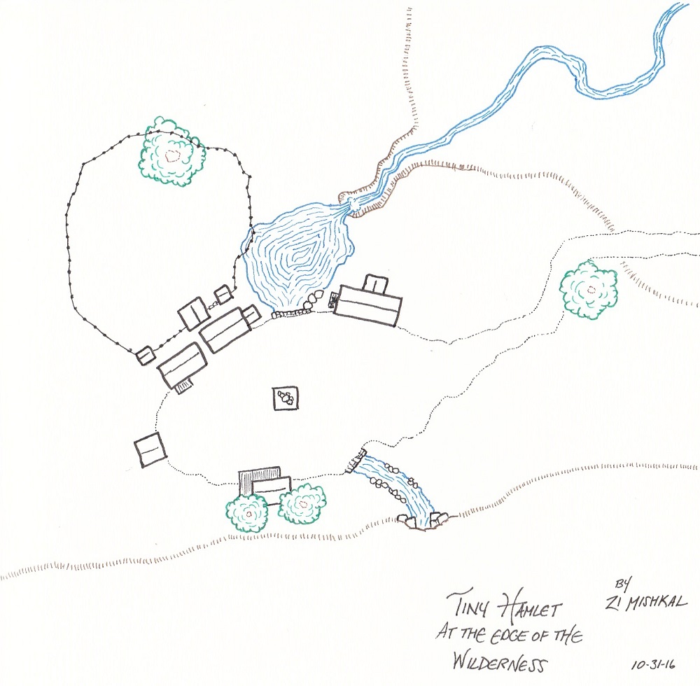
The map is a small settlement - it could be a hamlet or a large farm set somewhere near the edge of civilization. Most of the buildings are to the north of the central clearing, with a fenced in area for some livestock and an attached barn. There's a statue in the center of the clearing. It could be some old family relative or perhaps the founder of the hamlet. Maybe it's to the local deity.

to the south is another house with a large wrap-around porch. I think of this as the blacksmith, personally. Just to the right of the blacksmith is a stream that flows out of a cave opening, under the central area and into a pond on the north side. A small escarpment in the northeast allows the pond to escape as a waterfall into a small ravine. Lastly, some scattered trees dot the area, which is otherwise grassland.

Saturday, July 16, 2016

A quick map of the route to Valenhall...

It's as much an exercise in learning the capabilities of my new scanner as it is giving some perspective to the new geographical tidbits we learned about Arcadia after Distant Shores was released.


A few liberties have been taken with the map (obviously). I've extended the ice across the ocean (as would befit a world coming out of an Ice Age). I added a location in Azlant called "The Lost Light". It is a haunted lighthouse on the northernmost edge of the shattered continent. Most sailors will go no closer than visual range of the lighthouse. Port Valen was also given a location and some of the Akrandida mountains have been mapped (it is very unlikely to be the fullest extent of the range).

That's it. The scan went pretty well (this was hand drawn on graph paper). It could use some tweaking, but it's a good first try.

Saturday, May 21, 2016

Been fiddling with the tablet and drawing some maps...

Nothing big or exciting, just seeing what I can accomplish with digital ink. What do you think? I'm not entierly sold on the use of color or the hatching.

This could be the lair of a single hill giant or an ogre. 
I call this one "The Devil's Hole". It would make a good location for a tribe of goblins or kobolds. It's not finished. The name is, for me, reminiscent of something completely unrelated. Given a bit more time I could see releasing a larger scale version for in-game use. But first I'd have to work out scale issues and what not. (i.e. figure out what size grid people would find most useful).

Wednesday, March 23, 2016

A tabulated population of Avistan


Hi everyone!

Recently, the question came up as to what the population of some of the nations in Golarion were. While I know that the devs officially do not want to say (to give the GM some leniency within their respective worlds), I also know that this keeps coming up as a thread once every few years. So I decided to take an evening with the wiki pages and tabulate all the countries in Avistan. The result is the attached google doc. You'll have to save a local copy if you want to edit it.

A lot of the smaller settlements don't have figures and those figures really wouldn't matter in the grand scheme of things. In cases like this, I've assigned the following totals:

Hamlet: 50 pop
Village: 100 pop
Town: 500-1000 pop.
City: I haven't added anything to these. I'm hoping to get actual figures.

Furthermore, on the first page, I've added a column called "countryside population" which acts as a modifier to the city totals. This is to represent the number of people living on farms, etc... Its listed as a percentage of the city population. So, if you think twice as many people live outside of these named settlements, then you should add 200% to that column.

The spreadsheet is about 95% finished - enough to get a good sense of the relationship between different nations. If anyone has population / settlement figures to add to the spreadsheet, feel free to comment below or add it to this thread on the Paizo boards. I'll try to keep it up to date as much as possible.

Addendum: I've added some more fields on the first page where you can change the percent of people living in cities to alter the total nation's population.

Thursday, January 21, 2016

Giantslayer in Veridia

Our Kingmaker campaign is quickly drawing to a close and I've volunteered to start the next AP. I picked Giantslayer, but with a caveat. The party didn't really want to leave the country and story we've been working on for the past 3+ years. So I decided to move Giantslayer from Belkzen to Brevoy. It'll be 25 years after the start of  Kingslayer and there'll be all sorts of changes to Brevoy and the PC Kingdom.

Because the PCs will be going back and forth between their kingdom and Brevoy and because I need to place encounters and be able to figure out where things are - I'm putting together a 6 mi per hex map of the area. The starting town in Brunderton. It requires a bunch of rewrites, but less than you think.
Southeastern Brevoy at 6 miles per hex. Among the interesting features is having the Valley of Fire as "broken lands" as well as having the dark trees as "old growth" forest.